Project SwingSlide
Overview
Overview
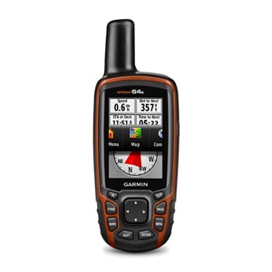
Project SwingSlide is a GPS/GIS based project to help parents who live in the town of Belmont, MA find a park for their children and know what types of features are at the park before they go to the park. The name of the project comes from my daughter, who refers to all parks as “SwingSlides”. This project began with a class at the Tisch Library at Tufts on GPS (Global Positioning System) and GIS (Geographic Information Systems). Utilizing a Garmin GPSMAP 64s borrowed from the Tisch Data Lab (shown in the figure below), data was collected and analyzed to create the interactive map at the bottom of the page.
Parents with kids are always wanting to take kids to the park. However, there are times that a child may want to play on a particular type of equipment. Project SwingSlide is intended for a mom or dad living in Belmont, MA to quickly ascertain which park they would like to go to. As you zoom in on the map, every swing, slide, jungle gym, etc. is mapped/marked on a convenient map. If a child wants to only play on large slides, parents can use the map to quickly see if a park is within in walking distance, driving distance and what play equipment is in the park as well.
Potential Users
This project with developed with parents living in Belmont, MA in mind. The target user will be anywhere between 18-55 in age and will have at least 1 child that is 9 months old or older. The median income for a family in Belmont will be around $105,859/yr and while that is a high income compared to the rest of the country, it may not be enough to purchase a single family home with a yard and room for a swing and slide…so instead the parents will most likely take their child to a park. The typical users in Belmont will walk, bike or drive to the park and take their children to the park several times a week. The parents want their children to be happy, enjoy the outdoors and run around and get plenty of exercise. The parents also hope to find playmates for children at the park as well as get some interaction with other adults.
User Persona
Kari is a 32 year old mom of two. She is a nurse and works a part time job. Her husband works full time and travels a lot. Most of the time she is at home with her two young children in the 3 bedroom condo they live in. She likes taking the kids outside everyday because they get bored cooped up in the house. The oldest child is 4 years old and likes to play on the jungle gym and go down slides. The younger child is only 2 and likes to sit in the swings and be pushed all the time. He can not sit on a normal swing by himself and must use one of the baby swings that holds him securely. Kari has a car, but likes to walk when the weather is nice. As kids tend to do, Kari’s kids get bored easily going to the same place every day. This includes the same playground. Fortunately, Kari happens to live in Belmont and has access to Project SwingSlide. Kari can pull up the website from her iPhone and easily see she lives within walking distance of three parks in Belmont and within a short (10 minute or less) drive of every park in Belmont. Since her kids like particular play things at parks, Kari can click on various icons and look at what is available at each park. Some days, her 4 year old wants to go down a BIG slide…she can easily find that in the app. Since each slide is categorized by size, she can see that there are large and even extra large slides at a couple of the parks close to her. She also knows that one of the parks does not have a baby swing available so her younger child will not like that park.
This project was a first attempt at mapping features of a park and analyzing the data to provide approximate travel times to users. In the future, this work could be expanded by utilizing big data and machine learning to automatically collect this data and update maps. For example, using a combination of data from satellite imagery and Google street view, machine learning could identify and tag all the items in parks automatically. There may be an issue with getting exact coordinates of each feature and this problem would need to be solved before every item could be fully geo-tagged. But, since this application does not require centimeter level precision, if the data could provide locations within 5-10 meters, then that would be good enough for most people.
Another future direction could be utilizing an IoT approach and actually incorporating IoT devices into each piece of playground equipment. If each item had a GPS tag when it was installed and a small transmitter included, then it could automatically be added to a map. However, this is probably not the most cost effective solution and probably would not get much traction from manufacturers of municipalities purchasing the playground equipment.
Date
December 1, 2019